- Welkom bij Meteo Service Forum.

Recente berichten
#1
Onweerskansen / Onweerskansen 2024 - Algemene...
Laatste bericht door Der RoX - Gisteren om 21:30Wat een enorme hoosbui hier eind van de middag, zelden zo'n bak water zien vallen hier 
#2
Plaats hier jouw eigen weerfoto's / 16 en 19-05-2024 Onweer Nijme...
Laatste bericht door dondertje127 - Gisteren om 20:10**Mislukt*
#3
Onweerskansen / Onweerskansen 2024 - Algemene...
Laatste bericht door 4seasons - Gisteren om 18:14Was hier net een waterbom gevallen, flitsen en een fikse onweersklap erbij
Wat "sfeer" beelden:
Wat "sfeer" beelden:
#4
Het weer in het algemeen / Lente discussietopic 2024
Laatste bericht door TMCThomas - Gisteren om 13:41Het lijkt geen zomerse start van de meteorologische zomer te gaan worden helaas.
#5
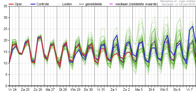
Het weer in het algemeen / Lente discussietopic 2024
Laatste bericht door vivalavida - za 25 mei 2024 - 20:35We hadden vandaag het kinderfeestje van onze oudste in het bos  veeeel heeeeeeel veeeeel modderpoelen. Het thema was helaas geen peppa pig, maar jeetje kan me dit niet herinneren van de afgelopen jaaaren.
Ik kijk wel uit naar een iets stabielere periode moet ik zeggen 8 mnd herfstig weer is lang
veeeel heeeeeeel veeeeel modderpoelen. Het thema was helaas geen peppa pig, maar jeetje kan me dit niet herinneren van de afgelopen jaaaren. Ik kijk wel uit naar een iets stabielere periode moet ik zeggen
8 mnd herfstig weer is lang #6
Het weer in het algemeen / Lente discussietopic 2024
Laatste bericht door Bubba - za 25 mei 2024 - 18:59Citaat van: olivetomato op za 25 mei 2024 - 17:39Mijn moestuin vindt het in ieder geval helemaal geweldig 😁.
Nou het mag ook wel wat minder hoor
Probeer maar eens onkruid te wieden of te schoffelen 
Leuk weetje trouwens las ik net op:weerplaza
1983 was nog natter dan nu, we staan nu op de tweede plek maar in 1983 kregen we dus na een kletsnat voorjaar een hele hete zomer
 De op één na warmste sinds 1901. Dus er is nog hoop, fingers crossed
 #7
Het weer in het algemeen / Lente discussietopic 2024
Laatste bericht door olivetomato - za 25 mei 2024 - 17:39Het wil ook maar niet hè, qua stabiel voorjaars- zomerweer? Dat gezegd hebbende... Overdag droog en een redelijke temperatuur, en dan 's avonds een bak regen (met optionele donderklap). Ik doe het ervoor 👍🏻. Mijn moestuin vindt het in ieder geval helemaal geweldig 😁.
#8
Het weer in het algemeen / Lente discussietopic 2024
Laatste bericht door TMCThomas - vr 24 mei 2024 - 12:22Helaas zijn de warme leden weer verdwenen, stabiel zomers weer lijkt er helaas nog niet in te zitten. Steevast zien we op een of andere manier lagedruk in onze regio terugkomen.

#9
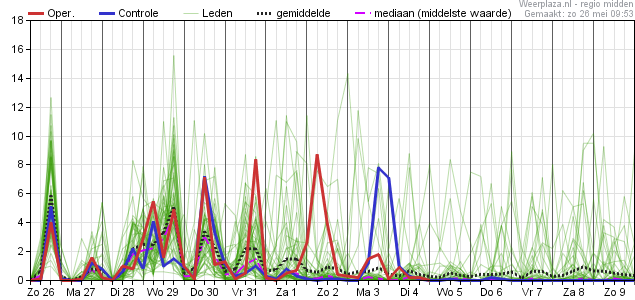
Onweerskansen / Onweerskansen 2024 - Algemene...
Laatste bericht door flyineddy - vr 24 mei 2024 - 12:16ESTOFEX komt ook met een Level 1 voor noordoost Nederland en een Level 2 voor het uiterste oost-noordoosten van Nederland, met name voor veel neerslag en een kleine kans op tornado's:
Je hebt geen rechten om deze bijlage te bekijken.
Eddy.
Je hebt geen rechten om deze bijlage te bekijken.
CiteerA level 1 and level 2 are issued for the Netherlands, central to E Germany mainly for excessive convective rainfall and to a lesser degree for tornadoes.
DISCUSSION
... central Europe between central France, BeNeLux, Germany, Poland, the Baltic States, Romania and the Alps ...
Despite rather poor lapse rates, the rich low-level moisture is "recycled" into low to moderate CAPE (up to 1000 J/kg, locally more along convergence zones and/or delayed vertical mixing) and allows another round of scattered to widespread, daytime-driven thunderstorms. Under mostly weak vertical wind shear, single cells, multicells and loosely organized clusters are the expected convective modes, and excessive rain is clearly the main hazard. The highest storm coverage is expected at the forward flank of a small cyclone over central Germany, where faint warm air advection and positive vorticity advection create synoptic lift that overlaps with moderate CAPE from Hungary into the Netherlands. This belt is therefore covered by a level 2. In contrast, clouds and rain as well as low-level stabilization quench thunderstorm activity at the cyclone's rear flank across the SW half of Germany.
Marginally large hail, copious amounts of small hail and localized severe wind gusts are secondary hazards, especially from Austria, the Czech Republic and central Poland east- and southward, where lapse rates are slightly steeper and capping is slightly stronger, allowing higher CAPE and therefore more discrete storms. The same applies to the eastern level 1 area across the W Ukraine, W Belarus and NE Poland, where a lack of synoptic lift in vicinity of the blocking anticyclone keeps thunderstorm coverage lower.
Low cloud bases and pronounced low-level convergence can also allow the spin-up of a few short-lived tornadoes, most notably at the nose of the warm air advection regimes across the Netherlands and NW Germany, where low-level wind profiles are best with 0-1 km shear around 10 m/s and pronounced low-level veering. A lack of insolation may be a limiting factor, though. Slightly enhanced tornado possibilities also stretch further along the most pronounced convergence zone across central Germany and Bohemia into E Austria.
Eddy.
#10
Onweerskansen / Onweerskansen 2024 - Algemene...
Laatste bericht door Armand - vr 24 mei 2024 - 10:19Nog even een korte update, we zien momenteel het buiengebied het zuidoosten van het land binnentrekken. Alhier is het ronduit koel met amper 13 graden in de stromende regen. Dit gebied met buiige regen trekt vandaag verder over de zuidelijke helft van het land. De noordelijke helft zit in de warmere lucht en hier zullen in de loop van de dag stevige (onweers)buien ontstaan. Grootste risico is opnieuw wateroverlast.
De buien boven de noordelijke helft kunnen pieken met lokaal 20mm/uur. In totaal kan er dan gemakkelijk 40mm vallen, lokaal wel meer. Harmonie komt zelfs met uitschieters tot 70-80mm! Een ander aandachtspunt is de neerslaghoeveelheid in het zuid(oosten). In het buiengebied ontstaat namelijk een lagedrukgebiedje, waardoor de neerslag in het zuiden gaat indraaien en daardoor langdurig kan blijven hangen. Hierdoor zijn in totaal ook neerslagsommen van 40mm of lokaal zelfs wat meer mogelijk:

Dus zowel in het noorden als in het zuiden kan er mogelijk behoorlijk veel regen vallen, met wellicht wateroverlast.
De buien boven de noordelijke helft kunnen pieken met lokaal 20mm/uur. In totaal kan er dan gemakkelijk 40mm vallen, lokaal wel meer. Harmonie komt zelfs met uitschieters tot 70-80mm! Een ander aandachtspunt is de neerslaghoeveelheid in het zuid(oosten). In het buiengebied ontstaat namelijk een lagedrukgebiedje, waardoor de neerslag in het zuiden gaat indraaien en daardoor langdurig kan blijven hangen. Hierdoor zijn in totaal ook neerslagsommen van 40mm of lokaal zelfs wat meer mogelijk:
Dus zowel in het noorden als in het zuiden kan er mogelijk behoorlijk veel regen vallen, met wellicht wateroverlast.
Powered by EzPortal